What is an Occluded Front?

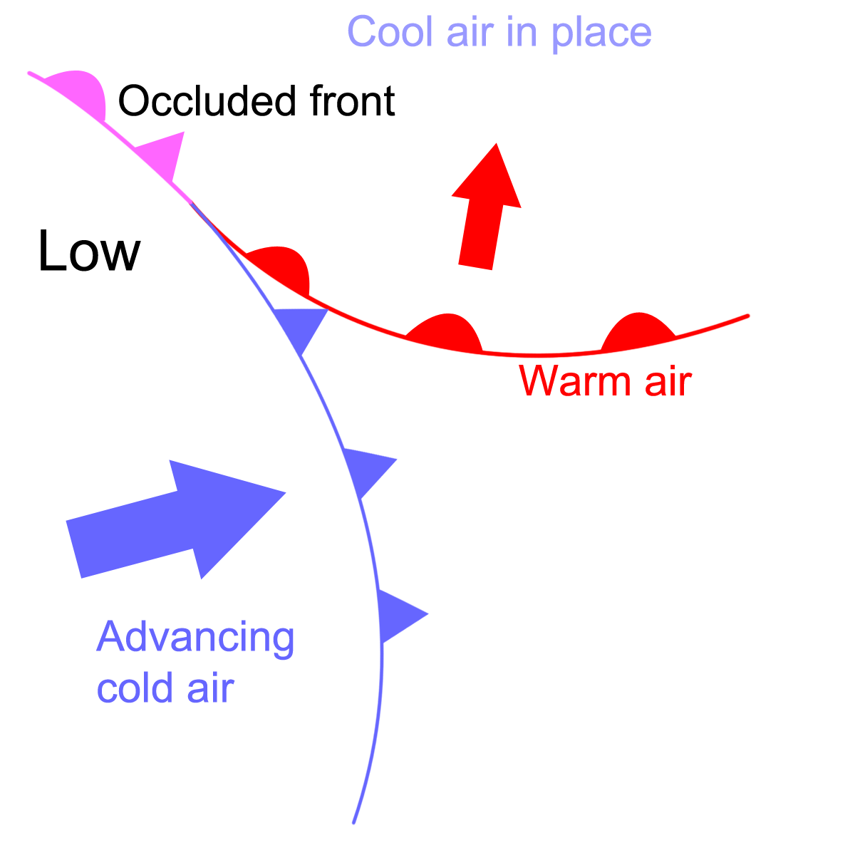
Occluded fronts are linked with areas of low pressure called depressions (more on these soon!). When a depression forms, there is usually a warm front and a faster moving cold front. The diagram below shows this. To the north of the warm front is the cool air that was in the area before the depression developed:

Diagram showing a slow moving warn front and a faster cold front behind it

The warm air mass is replacing this cool air and at its leading edge is a warm front.

As the depression intensifies, the cold front catches up with the warm front (remember it moves faster than the warm front). This is shown below. The line where the two fronts meet is called an occluded front:

Diagram showing the formation of an occluded front

When an occluded front passes overhead, you would feel changes in temperature and wind speed. Occluded fronts can generate quite stormy weather as they pass over.

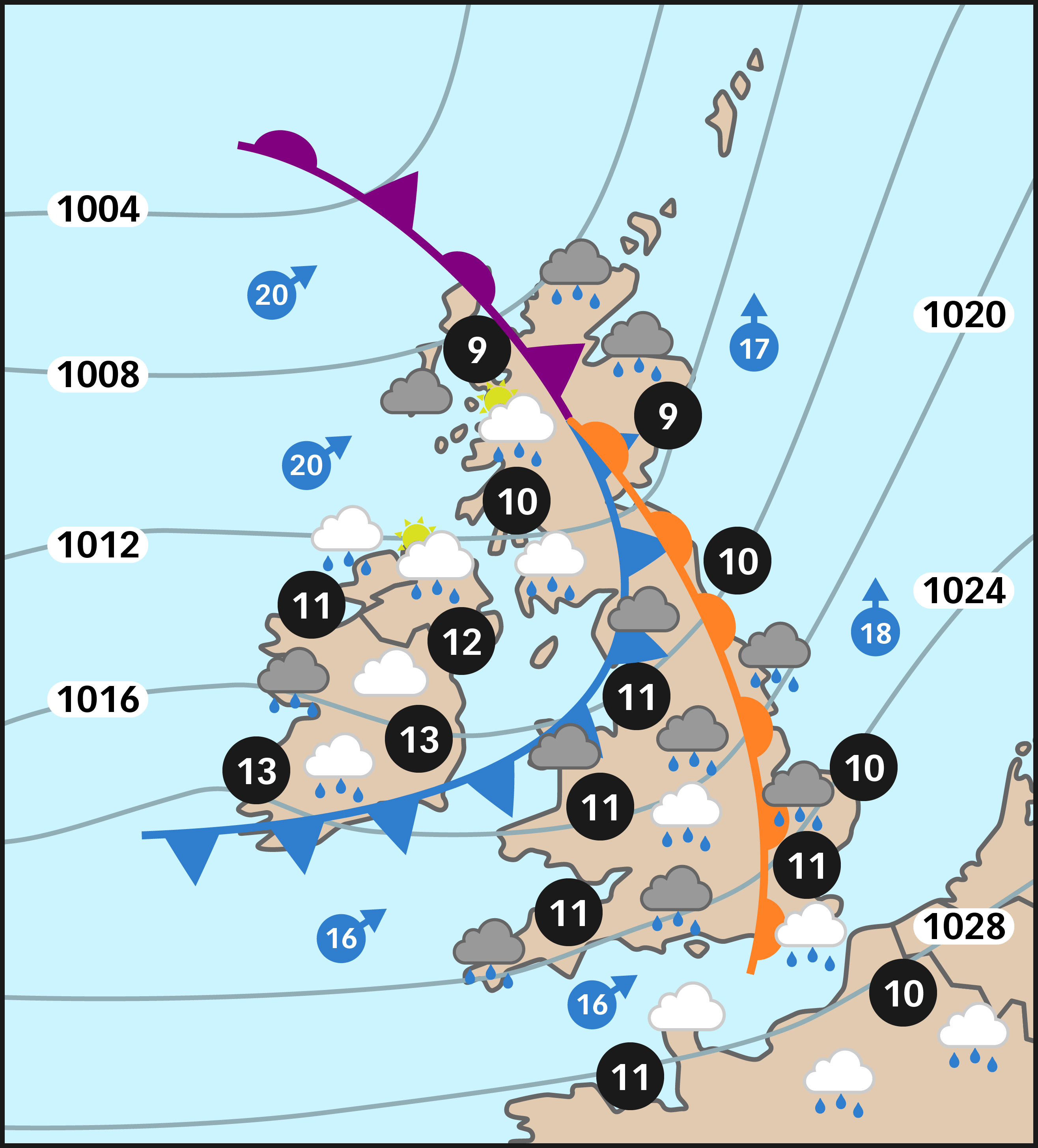
We are now going to look at a weather map from the Telegraph web site.  This will help us understand how to recognise an occluded front.

Excercise

The chart below shows an occluded front over the UK on the 25th March 1998.  Although it is old, it shows the formation of an occluded front clearly. The fronts are represented by the black lines (notice the different symbols used to indicate cold, warm and occluded fronts).  Here the fronts are moving in the direction that the wind is - in this case in an anticlockwise direction around the low E (see the lower map).  You can see that the weather conditions ahead of, within and behind the fronts are different.

British Isles weather chart for 25 March 1998. Daily Telegraph

[Source: Daily Telegraph]

Symbols on the map

  • Thin black lines: These are isobars. They link areas with equal air pressure. the values are pressures in millibars, with inches in brackets
  • Arrows: Direction of the wind (wind speed is shown in miles per hour)
  • Numbers in black circles: Air temperature in degree Celsius (degree Fahrenheit is shown in brackets)
  • Icons: Show main weather features such as light cloud, rain, sunshine, etc.
  • Thick lines: Fronts, either cold (marked with triangles), warm (semi-circles) or occluded (both marks)

Questions

  • Where is the occluded front?
  • What is the change in temperature ahead of, between and behind the  fronts?
  • What weather conditions change ahead of, within and behind the occluded front?

More about occluded fronts

There are two different forms of occluded front.  One is called a cold occlusion. A cold occlusion occurs when the air behind the occluded front is colder than the air ahead of it.  The cold occlusion acts in a similar way to a cold front. The colder air behind the front undercuts and pushes up the air ahead of it.

The other type of occluded front is the warm occlusion. A warm occlusion occurs when the cold air behind the occluded front is warmer than the air ahead of it.  The warm occlusion acts in a similar way to a warm front. The cold air behind the front is less dense than the even colder air ahead of it, and so it passes over the top of the colder air.